62 different areas throughout The City Of Brotherly Love
The largest concentration of parkland in Philadelphia (2,050 acres) is located on both sides of the Schuylkill River. On the east side, from the Philadelphia Art Museum in the south, beyond the Boat House Row and Kelly Drive. Cross a bridge over to West Fairmount Park from the Philadelphia Zoo, extending as far as City Line Avenue in the north. Wissahickon Valley Park continues along the tributary from the northeast.
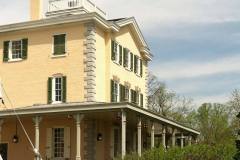
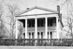
At the dawn of the 20th century, this was a wilderness area that provided relief from the heat and dust and congestion of Center City to a few wealthy families who built summer cottages on the hills above the river. Dozens of other landmark buildings, WPA structures and horse stables have been built in the park, and a few buildings in the city have been relocated to Fairmount Park for safekeeping. The Centennial International Exhibition of 1876 was the source of three buildings that have remained for posterity – Memorial Hall is occupied by the Please Touch Museum, Ohio House is open as a restaurant, and Sakura Pavilion adjacent to the Horticulture Hall.
Many sites are open to the public, while others have been adapted for reuse by private businesses, residences and park offices. Check the Fairmount Park website((Fairmount Park Digital Guide (Fairmount Park Conservancy) )) for availability and closures.
Page will reload with with the gallery you select below:
Penn's Philadelphia and Early Signs of Extra-urban Development
After receiving an enormous land grant from the King of England in 1681, William Penn promptly began to establish the layout of his new colony, Pennsylvania. He located Philadelphia between the Delaware and Schuylkill Rivers, ensuring that ships would have easy access to the colonial capital. While this piece of planning reflected much foresight, the boundaries that Penn initially envisioned for his city encompassed an unmanageably large quantity of land. In his revised plans, he excluded a large area from the northern and western parts of the city and designated this tract “the liberty land of free lots.” He also decreed that 100 hundred acres of this land and two lots within city limits would be granted to anyone who bought 5,000 acres in the colony. Not until 1854 did the “Liberties” (as they came to be known) become part of Philadelphia proper.
Officially founded in 1682, Philadelphia experienced prosperity and rapid population growth over the next few decades. The city’s geographic location facilitated trade, and Penn’s commitment to religious tolerance within his colony proved equally attractive.
By 1720, roughly 10,000 people could call themselves Philadelphians.
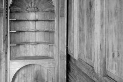
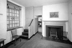
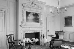
Like Penn himself, most of the early settlers were Quakers, and while their numbers included merchants, far more were artisans. At the start of the eighteenth century they were joined by immigrants from Germany, Ireland and Scotland.((Schuylkill River Villas HABS PA-6184))
The formation of Fairmount Park
In an effort to deter industrial development in the immediate vicinity of the Waterworks, Lemon Hill was purchased by the City at a cost of $75,000 in 1844. It continued to be operated as a beer garden and was not dedicated for public use until 1855. Two years later Sedgeley, which once had been part of the original Moms estate, was acquired for $125,000, largely through the efforts of concerned citizens. The original driving force being “to provide a place in which poorer people of our fellow citizens and their families might find health and recreation”. Shortly thereafter, the land that had separated Lemon Hill and the Fairmount Waterworks was acquired through a court action. It was these three properties that comprised the original East Park and totaled 110 acres.
With the consolidation of the County of Philadelphia into the City of Philadelphia in 1854, the West Philadelphia Waterworks, located on the west side of the Schuylkill south of Girard Avenue, came under City ownership. Next to this property was Solitude and upon the death of its owner, Granville John Penn, in 1867, the City purchased the property. A year earlier, Lansdowne, a 140 acre estate, was purchased from the Baring family of Great Britain.
In March of 1867, the General Assembly of the Commonwealth of Pennsylvania formed the Fairmount Park Commission to maintain the Park. They began to condemn, purchase, and receive land for the benefit of the citizenry. George’s Hill, donated in 1868 by Jesse and Rebecca George, was considered the most important of these gifts, containing eighty-three acres. As land was acquired, most of it was left in a natural state; however, small architectural elements such as rustic pavilions, footbridges, and park guard stations were constructed at several sites. In 1876, the Centennial Exhibition was held in Fairmount Park and drew almost ten million people, which broke all previous visitation records to an exhibition in any country. The Park houses and picturesque surroundings were used as selling point to gain support for the Centennial to be held in Philadelphia.
By 1914, Fairmount Park proper (Old Park, East Park, West Park, Wissahickon, and Schuylkill) comprised of 3,418.47 acres with 27 miles of macadamized carriage drives, 44.5 miles of footwalks, 12 miles of bridle paths, and 42.6 miles of macadamized drives and dirt roads. The boundary around Fairmount Park proper stretched 33.7 miles.((Stephenson, Courtney Cockrell A Promotional Plan for Fairmount Park. University of Pennsylvania Thesis in Historic Preservation 1998 ))
To make way for open parklands to protect the water supply, several factories along the river were targeted by the commission for relocation. Pollution from the Belmont Refinery that opened in 1865 and the Washington Print Works near the falls bridge were a threat to the water intake at the Fairmount Water Works.((Gibson, Jane Mork (1990) “Workshop of the World – Philadelphia“, Oliver Evans Press ))
Schuylkill Banks – Bicycle paths along the river in the heart of the city. Connection to paths in Fairmount Park, continuing all the way through Manayunk to Valley Forge.
Boathouse Row – List of the twelve boat houses on Kelly Drive near the Art museum for rowing teams competing in “shell” races on the Schuylkill River.